foreword
"Green wave belt is a concept that has existed in the transportation industry for a long time. Daily interaction relies on its long-term technical accumulation in big data and artificial intelligence. By fusing and calculating its own data, traffic control department data and third-party data, it integrates cycle time, surrounding scenes, road traffic direction, driving speed and other factors. The algorithm is used to calculate the best signal and control parameters, quickly form an urban green wave scheme, and can be dynamically adjusted according to the real-time traffic flow and road conditions on the road. In the case of having as little impact on the surrounding traffic as possible and making maximum use of the existing transportation infrastructure, the complexity of green wave signal control coordination and optimization is greatly reduced, allowing the traffic control department to dispatch and manage the traffic flow of the road network with a click of the mouse, so that "Photoshop" can be turned into "Meitu Xiuxiu" in seconds. At the same time, it helps the urban traffic control department to build a digital traffic management system at a very low cost, and quickly improves the fine and intelligent water of urban road traffic signal control. Realize "100 times efficiency" with "100% rate", help the construction of a transportation power, and create a safe, orderly, smooth and civilized road traffic environment for the masses to travel. "
Special thanks to the Hangzhou traffic police. Hangzhou is the first city where our number of smart green waves have landed. It is also under the trust and professional guidance of the Hangzhou traffic police that we have really polished this product and continuously optimized it. Since October last year, we have co-created and strengthened the construction of green wave belts with the traffic police brigades of Hangzhou districts, changing the original mode of setting up long-distance green wave belts, turning 3-5 intersections into a group, turning lines into faces, and increasing the speed by about 20%. At present, there are more than 200 green wave belts built in Hangzhou, with a mileage of more than 300 kilometers, all over the urban area of Hangzhou. In their daily travel, Hangzhou citizens have unknowingly enjoyed the smooth convenience brought by the green wave belt.
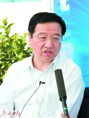
Yesterday, Fang Yi, founder and CEO of Daily Interactive, accepted Love’s analysis and systematically shared his views and successful practices on urban traffic congestion management.

Fang Yi
Founder and CEO of Daily Interactive
Outstanding graduate of Zhu Kezhen College of Zhejiang University. Winner of the 4th "Youth May 4th Medal" and winner of the 10th "Youth Entrepreneurship Award".
The current executive committee of the All-China Federation of Industry and Commerce, the National Association for Science and Technology, the National Youth Federation, the Vice of Young Entrepreneurs, the National Information Security Standardization Technology Association, the Vice of Zhejiang Youth Federation, the Vice of Zhejiang Federation of Industry and Commerce (Provincial Chamber of Commerce), the Vice of Zhejiang Chamber of Commerce, the Vice of Hangzhou Federation of Industry and Commerce, and the Hangzhou CPPCC. The founded Daily Interactive successfully landed in the growth enterprises market in 2019 (code: 300766), becoming the first data intelligence enterprise in China to list on class A shares.
01 Urban traffic congestion management is the world’s most prominent problem in urban diseases, and daily interactions seek new breakthroughs in solutions
Love Analysis: Big report, we need to speed up the construction of a transportation power and figures, and improve urban water governance. Traffic congestion, as the most prominent and most global problem in "urban diseases", is very realistic and challenging to manage. At present, what are the common painpoints in the traffic control department in optimizing urban road condition management and serving citizens’ travel?
Fang Yi: Big, to accelerate the construction of a transportation power and digital, the Ministry of Transport and the Ministry of Science and Technology have also jointly issued the "Opinions on Accelerating the Construction of a Transportation Power Driven by Scientific and Technological Innovation" and the Outline of the Medium and Long-term Development Plan for Scientific and Technological Innovation in the Transportation Field (2021-2035). The development of the strategy and related policies has provided a good policy environment for the development of our data intelligence field and pointed out the development direction.
During the "14th Five-Year Plan" period, our country’s economy will transition to high-quality development, and the volume of passenger and freight transportation will continue to grow. The main problems facing transportation governance are poor traffic flow in the core areas of cities and insufficient smart transportation coordination. According to official statistics, the number of cars in 70 cities in our country has exceeded 1 million. Traffic congestion is the most common, most frequent, most prominent and most world-wide problem in urban diseases, and its governance is very realistic and challenging. According to field observations and industry exchanges, we found that the current traffic control departments generally have the following pain points in optimizing urban road condition management and serving citizens’ travel:
First of all, the number of urban cars in our country, the number of drivers surged, the urban population continues to increase, traffic facilities gradually complex, but the city’s intersections, road sections of the digital construction is still not high, the lack of intelligent traffic coordination, data sharing system has not yet formed, resulting in the city’s overall road conditions online monitoring and analysis is difficult, single point intersection timing intelligent low, many intersections often empty or congestion phenomenon.
At the same time, traffic control departments are mostly based on manual experience, lack of big data support, and the effect of intersection signal timing after manual adjustment cannot be quickly and accurately verified. Closed-loop iterative optimization is difficult to achieve, and there is a lack of sufficient coordination between different intersections and regions. It is difficult to cope with the complex traffic conditions that change in real time throughout the region. Unreasonable single-point green signal ratio settings will have a significant impact on the traffic efficiency of intersections.
At present, many cities commonly use Australia’s SCATS (Sydney Coordinated Adaptive Traffic System) and Europe’s SCOOT (Split Cycle Offset Optimizing Technique) system, its timing capabilities, adaptive capabilities, although very powerful, but data collection through urban roads coil or geomagnetic induction to achieve, its ground sensing equipment is often due to urban road planning adjustment, perennial traffic flow and frequent damage failure, and SCATS and SCOOT system is not "intelligent", timing personnel need "code level" ability, through the input of complex code scripts for timing, the use of high threshold, and the system for traffic police repeated temporary adjustment without "memory ability", it is difficult to precipitate experience, the formation of "reuse", can not flexibly respond to the ever-changing urban traffic conditions.
Finally, the investment in transportation infrastructure in various cities is huge, with hundreds of thousands of intersections at every turn. It is difficult to get through the data of different suppliers. The cost of "one game of chess" transportation intelligence in the entire city and region is high, and the hardware investment is large and the effectiveness is small.
In view of the above situation and pain points, Daily Interactive hopes to use cutting-edge technologies to assist in the innovation of traffic management concepts, management methods, and management models, and to improve the modernization, informatization, and intelligent water of traffic governance. This year, Daily Interactive has created a "Digital Smart Green Wave" product (hereinafter referred to as "Digital Smart Green Wave") for the field of smart transportation. This product can help the traffic police department to efficiently complete the intelligent timing of signal lights and the intelligent coordination and optimization of green wave routes, and realize the digital construction and intelligent scheduling management of road network traffic flow, better serve citizens’ travel, and improve the traffic management water in various cities.
In early 2022, Wenzhou City, Zhejiang Province plans to build (Wenzhou) Data Intelligence and Security Service Innovation Park (ie "Shu’an Port"). Daily Interactive has been deeply involved in it in the early days. When Shu’an Port is completed and operated, "Smart Transportation" happens to be released as Scenario 001. We hope that by relying on the establishment of Shu’an Port, we can make full use of our massive and vivid mobile Internet big data and capabilities, and deeply integrate multi-party dynamic data from traffic management departments, map service providers, and third-party data intelligence service providers for joint calculation, build a localized business system, and provide traffic management tools for traffic control departments to carry out intelligent application in the field of smart transportation.
Love Analysis: Compared with the traffic lights and manually coordinated green wave belt solutions of the traditional timing scheme, what innovations and breakthroughs have been made in solving the above pain points of the traffic control department by the "digital intelligence green wave" advocated by Daily Interactive?
Fang Yi: The so-called green wave belt is not a new concept, but a concept that has existed in the field of transportation for a long time. It refers to the fact that on a designated traffic line, when a vehicle travels at a specified speed, the signal controller adjusts the green light start time of each intersection that the traffic flow passes through according to the distance of the road section, so as to ensure that when the traffic reaches each intersection, it just encounters the "green light", thereby improving the overall traffic efficiency of the traffic line.
Our "digital intelligence green wave" product will use big data intelligent means to analyze the comprehensive traffic flow at intersections, optimize the single-point green signal ratio, improve the utilization efficiency of intersections under large traffic flow, and screen out the traffic arterial intersections suitable for the construction of green wave belts. By considering factors such as cycle time, surrounding scenes, road traffic direction, and driving speed, the algorithm is used to calculate the best signal and control parameters, increase the green wave coordination control, and ensure the smooth passage of vehicles on regional arterial roads by accurately segmenting the timing of intersection signals, thereby reducing delays and stopping times, and achieving the goal of "stop at most once".
The biggest feature of the daily interactive "Digital Intelligence Green Wave" product is to connect and connect the data layer, and conduct data mining and analysis of traffic scenes such as traffic flow distribution, signal control characteristics, intersections and road characteristics, providing traffic distribution, green wave recommendation, green wave optimization and other service components, and then support specific operations such as intersection/road network visualization configuration and intersection coordination relationship research and judgment in specific traffic management applications, so as to achieve "data characterization, feature serviceization, and service application", allowing urban traffic control departments to analyze, respond to, and monitor road conditions in real time, especially for traffic police to quickly and dynamically adjust the timing of intersection lights under their jurisdiction according to real-time road conditions.
Compared with the traditional timing scheme, the "digital intelligence green wave" product can be quickly optimized according to the traffic flow data of the road surface, rather than the "fixed" scheme under the traditional timing, which is more practical and flexible; compared with the manually coordinated green wave scheme, the "digital intelligence green wave" product is supported by traffic flow data and intelligent algorithms, reducing the heavy dependence on expert experience, and the operation is simpler. There is no need for the front-line traffic police to master complex codes. After only one hour of simple training, the front-line traffic police can master the system proficiently, and can realize the one-click configuration of the green wave scheme. It can also be used to fine-tune single intersections and road sections by dragging and dragging. At the same time, digital intelligence green wave can be based on the overall coordination and control of the entire region to avoid the overall inefficiency of regional traffic caused by the lack of systematic thinking and local optimization of various intersections and road sections.
02 Daily interactive "Digital Intelligence Green Wave" products help urban transportation upgrade from "manual transmission" to "automatic transmission"
Love Analysis: What is the general working principle of the "Digital Intelligence Green Wave" product? During this process, what core resources and technical capabilities have been mobilized by Daily Interaction to ensure the intelligence, efficiency and safety of the "Digital Intelligence Green Wave" product?
Fang Yi: Our "Digital Intelligence Green Wave" product, combined with Internet big data, provides personalized green wave signal control solutions in time periods, and conducts regular monitoring of green wave road sections, and makes decision-making and timing for green wave solutions that meet requirements, so as to realize the digitalization of road network traffic flow and intelligent scheduling management. Specifically, it can be understood from the following aspects:
Figure: Schematic of the solution architecture of the daily interactive "digital intelligence green wave"
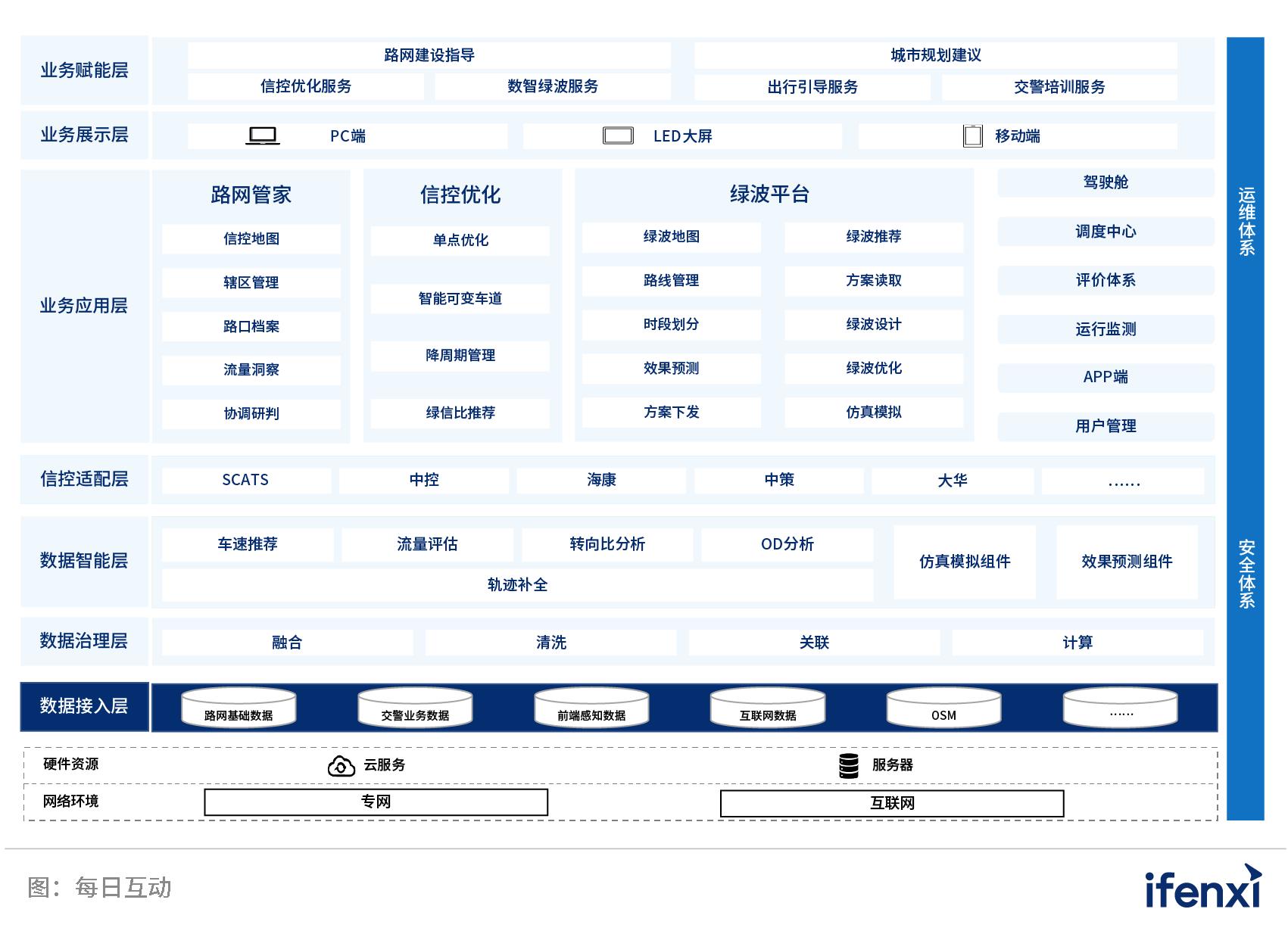
Our "Digital Intelligence Green Wave" product uses big data joint computing as the underlying infrastructure to maximize the security of data flow computing. This is because, although the massive data of daily interaction is given to the system at the statistical level under the green scene, which fully complies with the requirements of the Personal Information Protection Law, Data Security Law and other relevant regulations, it also needs to integrate the data of the traffic control department and even third parties. Therefore, it needs to enter the private network through the border and integrate the data in the private network for computing to provide services for upper-level applications. In order to ensure product and data security, all the data are put on the state-owned big data joint calculation for joint calculation, to ensure that the original data source can enter and exit, can be counted and not recognized, can not be used, the algorithm is transparent and easy to supervise, and the calculation is safe and efficient.
In terms of basic capabilities, Digital Intelligence Green Wave connects with rich data sources, and uses a powerful system inside Daily Interactive – "DiOS Data Intelligent Operating System" for data governance and fusion calculation, generating signal control scheme suggestions. We use our own big data to perceive real-time traffic flow data on the road, and at the same time, under the coordination of the traffic control department, we will also access the traffic control department’s road network basic data (such as traffic lights, lane lines, etc.), traffic police business data, infrastructure sensing data, etc. for fusion calculation and cross-validation. In the future, it may even be integrated with more third-party maps and data from travel service providers, so that the traffic control department can make a more three-dimensional judgment on traffic flow and road conditions. So how do we manage and calculate so many sources of complex data? This requires the use of the DiOS data intelligent operating system. DiOS can fully mobilize the company’s core capabilities in digital modeling, security computing, visual intelligence, intelligent transportation, etc., perform fusion calculations on the basis of data governance of all parties, and "scene" all kinds of traffic data. It is used to analyze and mine the traffic flow characteristics and travel OD characteristics of various intersections, road sections, and regions, so as to generate corresponding signal control scheme suggestions, and provide simulation components to facilitate the simulation and prediction of the effects of different signal control schemes.
In terms of business applications and empower, our digital intelligence green wave is connected with SCATS and other systems through API and RPA, so as to carry out real-time transmission and execution of signal control solutions and support automatic delivery. At the same time, based on the regional and road network traffic characteristic data, the daily interaction provides functional modules such as road network housekeeper, signal control optimization, green wave, cockpit, operation monitoring, etc., which can perceive, analyze, and dynamically adjust and optimize the information control measures of the road network. Based on the above functional modules, the urban traffic control department can easily implement three-dimensional business applications such as macro-urban planning suggestions to mid-scale road network construction guidance and digital intelligence green wave services through self-filtering maps, green wave design, program delivery, effect prediction and optimization.
It is worth mentioning that the digital intelligence green wave can also carry out the overall coordination and system optimization of regional traffic in a "game of chess" style. In order to avoid the green wave belt in a certain direction destroying the traffic efficiency of the road crossing it, when the horizontal road is made into a green wave belt, our "digital intelligence green wave" product supports a traffic light intersection as the center, and all intersections in the area are aligned with it, so that the intersecting routes and directions can be matched into green wave belts to carry out the overall optimization of regional traffic "game of chess". Of course, traffic is impermanent, and traffic flow is constantly changing in real time. Therefore, the digital intelligence green wave must have the ability to respond to emergencies and continuously iterate and optimize. In the actual traffic management process, it is not realistic to pursue green lights at all intersections. Here, the traffic control department needs to make value judgments. In order to prevent the situation of "snakehead biting snake tail", Digital Intelligence Green Wave also supports "temporary solutions". Once a temporary emergency such as a traffic accident occurs at an intersection or road section, the signal light control can be quickly restored to the original state. When the temporary emergency is over, it can be restored to the green wave state, thereby eliminating traffic pressure. In addition, Digital Intelligence Green Wave can also use technologies such as short-term flow forecasting and variable lanes to make intelligent iterations of the green wave solution and build a closed-loop urban traffic management business.
Finally, it comes to the specific use level. One of the major advantages of our digital intelligence green wave products is the ease of use. The horizontal axis is a road, and the vertical axis is the time axis. When the left signal light phase is selected, the right signal light phase can be automatically aligned with one button. Through this relative alignment, the regional green wave band scheme can be quickly realized. With the assistance of the machine, the difficult "photoshop" can be changed into "Meitu Xiuxiu" in seconds, which greatly reduces the complexity of green wave signal control coordination and optimization, allowing the traffic control department to dispatch and manage road network traffic flow with a click of the mouse.
Love Analysis: What are the core values of "Digital Intelligence Green Wave" products for urban traffic management and people’s livelihood? What kind of cities and road sections are they mainly suitable for?
Fang Yi: From the working principle above, you can see that our "Digital Intelligence Green Wave" product is based on the Internet-side big data fusion calculation, and builds urban green wave belts at a very low cost to help urban traffic control departments build digital traffic management systems, perceive and analyze road profiles in real time, and provide rational construction suggestions to quickly improve the fine and intelligent control of urban road traffic signals, creating a safe, orderly, smooth and civilized road traffic environment for the masses to travel.
It is worth mentioning that our "Digital Intelligence Green Wave" product does not waste any sensors, but makes maximum use of the existing existing facilities and aggregates the data together to achieve "cross-domain data fusion" to provide mutual verification for the urban traffic control department. For example, in case of some extreme situations, the daily interactive traffic flow data changes rapidly, and the traffic control department can use its own data to calibrate the daily interactive traffic flow data; similarly, the daily interaction can also infer the unreasonable traffic facilities data of the traffic control department, and then complete it.
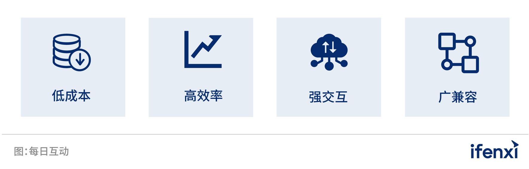
Figure: The main advantages of the daily interactive "Digital Intelligence Green Wave" product
From the perspective of the scope of application, as long as it is a road section that has realized online control, it has the application basis of "digital intelligent green wave". At the same time, the daily interactive "digital intelligent green wave" product has its own set of metrics, such as the repetition rate of the number of vehicles entering a certain intersection and leaving the intersection, etc. We will make a comprehensive judgment based on the location of the road section and surrounding facilities. For example, we find that a road section is equivalent to a tunnel, and the repetition rate of cars entering and leaving is very high. Then we consider this road section to be a commuter road and suitable for green wave belts.
Love Analysis: It is understood that the daily interactive "Digital Intelligent Green Wave" products have been launched in Hangzhou, Wenzhou, Huzhou and other cities, and have received good feedback. So, can you systematically introduce the company’s construction ideas when helping urban traffic control departments implement the "Digital Intelligent Green Wave" project?
Fang Yi: From a physical perspective, the construction ideas of our Digital Intelligence Green Wave project can be divided into the following steps to achieve a closed loop from concept communication, diagnosis, design planning to scheme optimization and solidification.
The first is the concept submission. We will first throw out our understanding of urban traffic management, fully discuss with the traffic control department, and promote the two sides to reach an agreement on the concept; then, we will clarify the daily interaction based on the underlying data to empower the front-end business with intelligent algorithms, emphasizing the traffic control department, especially the front-line traffic police as the user experience, from the traditional industrial control field thinking mode to the Internet-oriented C-end thinking mode, improve the ease of use of the front end, and do not need to change any of the original urban traffic construction plan, which can be completed at a very low cost.
The second step is to start planning and design. The daily interactive "Digital Intelligence Green Wave" product uses the data of mobile Internet big data, traffic police departments and map service providers to automatically jointly calculate and generate roads suitable for green wave construction in cities, and supports manual intervention of recommended green wave road sections, which can be added, deleted and modified according to the actual situation. For example, in the Hangzhou Green Wave Belt project, we found more than 700 kilometers of roads suitable for green wave construction in Hangzhou based on our own measurement standards, and submitted their distribution map to the Hangzhou traffic control department for review and discussion.
The next step is to configure the green wave. Digital Intelligence Green Wave can combine road network data and data such as the speed and flow of corresponding road sections and intersections to intelligently recommend a number of road sections that are most suitable for the construction of the green wave belt, and calculate detailed green wave configuration plans to assist in the final green wave belt construction decision. The traffic police department can select specific road sections for the "green wave scheme" effect experience according to our recommendation results. Then, we use visual intersection stewards to achieve comprehensive input and visual display of green wave construction information such as signal infrastructure, channelization, and flow; at the same time, the road network stewards will integrate information such as road section length, historical vehicle speed, and road section characteristics to generate intelligent recommended vehicle speeds, providing speed guidance for the design of the green wave scheme and ensuring the green wave effect.
Next is the division of time periods and scheme design. Speaking of which, we have to mention the great advantage of our smart green wave products that are easy to use. Smart green wave supports the adjustment and optimization of green wave bands by simple dragging on the time and distance diagram. It can be adjusted individually according to different scenarios (schools, scenic spots), different time periods (morning, evening peaks, daytime peaks), different periods (working days, weekends), etc., and multiple green wave scheme designs for specific intersections and road sections can be carried out. The optimal green wave scheme can also be selected according to the monitoring data and control experience of the traffic control department on specific road sections.
Single-point optimization is also very valuable. In this link, we can combine intersection flow data, intersection characteristic data and intersection signal control data, and accurately optimize the single-point signal control scheme of all intersections in the area to produce a single-point recommended timing scheme divided by time period, which can be automatically or manually issued, or sent to the signal light control system after manual intervention of the single-point recommended timing scheme.
Finally, to the practice running and program optimization, solidification link. We will assist the traffic control department to optimize the overall and single-point green wave scheme in the selected road section for partial or comprehensive practice running, and real-time operation monitoring of the program effect, according to the actual regional, road network program application and then optimized, submitted to the city traffic control department for confirmation, so as to achieve the solidification of the green wave scheme for different intersections and different time periods.
Figure: Daily interactive intelligent green wave belt construction idea schematic
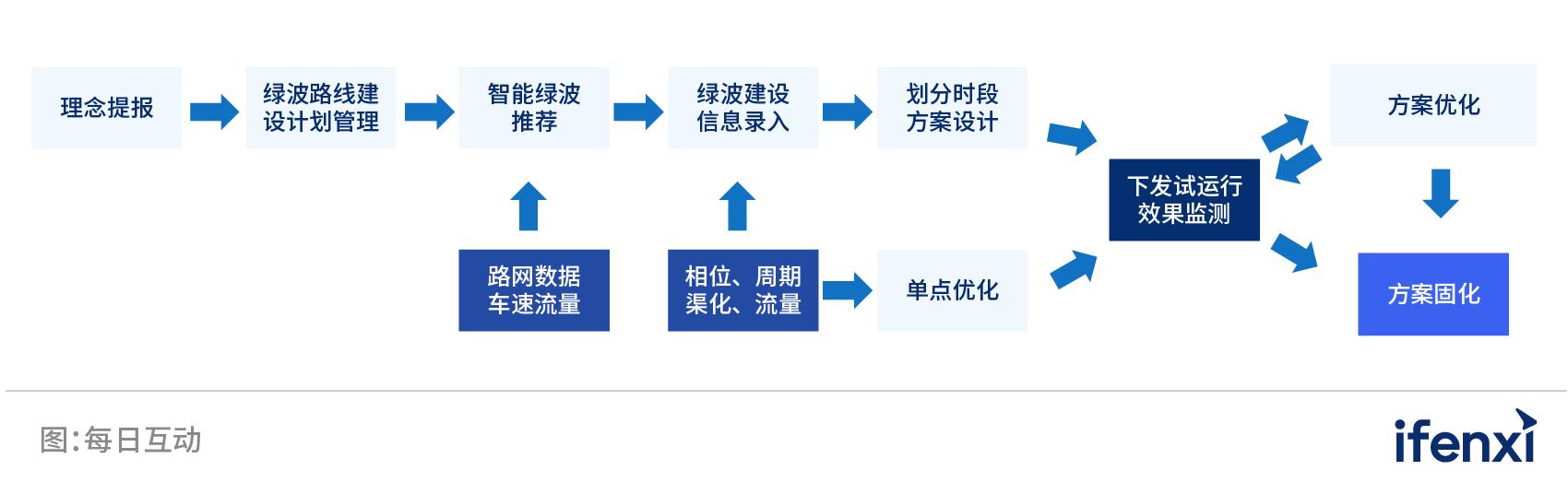
In addition, from the perspective of specific service methods, the daily interactive "digital intelligence green wave" project construction process includes four steps of pilot mode, deployment, product use training, and product optimization and upgrading. During the pilot period, the daily interaction can provide some selected road sections of green wave belt construction and promise corresponding results, providing free training and free product iteration and upgrade services during the maintenance period.
Love Analysis: Can urban transportation be graded with reference to autonomous driving? What is the significance of this in helping smart city governance upgrade?
Fang Yi: Just as autonomous driving can be divided into five levels according to the degree of autonomy from "fully manual to fully automated", we believe that the degree of digital intelligence in urban traffic can also be graded according to the degree of intelligence in the control of traffic lights at various intersections in the city. Therefore, we have developed the "Smart Transportation 6L" classification concept.
Figure: Daily interactive "Smart Transportation 6L" grading concept
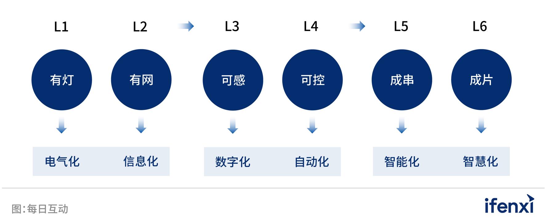
Level L1 means that there are signal lights at the intersection, which can be used for basic traffic control. Level L2 means that the signal lights at the intersection are connected to the Internet, and the traffic police can issue instructions remotely for single-point regulation. Level L3 is based on L2, and can perceive digital information such as the queue length and speed at the intersection through radar, cameras, geomagnetism and other equipment installed at the intersection, as well as big data on the Internet. Level L4 can analyze and model the data uploaded at the intersection to form a dynamic, data-guided closed-loop control. Level L5 is based on L4 to realize intelligent coordination of multiple intersections, such as the construction of "digital intelligence green wave belt". Level L6 is to achieve intelligent road management and control, that is, based on data modeling and analysis of regional road characteristics, business districts, schools, etc., it can achieve fine coordinated control of multiple intersections and comprehensively improve regional road functions.
The development process and scale of cities in our country vary greatly, and the investment progress of transportation infrastructure varies widely. Even in some relatively developed cities in the south, a large number of signal lights in the city may still be single-point level and have not been networked. Through the "Smart Transportation 6L" grading concept, the daily interaction can be based on the same language and measurement system with local traffic control departments to help cities find the specific coordinates of different intersections and road sections, and combine the urban transportation construction plan and budget of the year to communicate the upgrade plan of different intersections and road sections, such as upgrading from L1 to L2, or directly skipping to L3. At the same time, based on the agreed upgrade path, the daily interaction can complete the intelligent upgrade of urban transportation facilities at designated intersections and road sections within a certain period of time as agreed, and cooperate with cities to flexibly arrange the upgrade progress. This can greatly reduce the pressure on fiscal expenditure in each year, making the intelligent upgrade of urban transportation visible, controllable, and low-cost. It is expected that the daily interactive "digital intelligence green wave" products will initially be centered on the Yangtze River Delta and then rolled out nationwide.
03 Daily Interaction empowers domestic traffic intelligence with data intelligence core capabilities
Love Analysis: What are the plans for daily interaction in the future in terms of digitalization and intelligent upgrading in the field of transportation?
Fang Yi: In the field of transportation, we mainly have the following two aspects of planning:
In terms of urban transportation, as mentioned earlier, daily interaction will use big data in a very convenient way to achieve initial intelligence of urban transportation. The current is the "smart green wave" solution, and in the future, daily interaction will also use Wi-Fi sensing systems or other new road condition sensing systems in a more refined way, coupled with big data to close the loop, greatly reducing the construction cost of intelligent urban transportation.
In terms of high-speed transportation, Daily Interactive is currently cooperating deeply with Zhejiang Gaoxin Technology joint stock company, a subsidiary of Zhejiang Jiaotong Investment, to help it further deepen its expressway informatization business with DiOS data intelligent operating system; at the same time, Daily Interactive also uses its own technical capabilities to create an early warning system for abnormal situations on expressways, and actively participates in the management of abnormal situations such as highway throwing. Specifically, we use the high-speed "gantry" ETC data to calculate the instantaneous speed of each vehicle entering and leaving and the interval speed between the two gantries, and according to the speed and traffic flow changes between the gantries, combined with expressway cameras, quickly find problems on specific sections of the expressway and give timely warnings to reduce the risk of expressway accidents. At present, the early warning system for abnormal conditions on expressways has been able to detect abnormal sections in about one and a half to two minutes, and inform the expressway traffic police two to ten minutes before the accident so that they can arrive at the abnormal section in advance and quickly for processing. In the future, the daily interaction will further dig into the management scene of high-speed traffic, and continue to work hard to improve the informatization of expressways and reduce the accident rate of expressways.
Love Analysis: What other perspectives do you want to share on road network digitalization, urban transportation governance, and other aspects?
Fang Yi: Now there is a new trend in traffic governance to apply radar and video, but the cost and edge computing cost of this solution are relatively high. In recent years, our domestic computing resources have been greatly improved, but the computing power is ultimately limited, and the rational use of computing power resources has become the key to reducing costs and increasing efficiency. I think that many vehicles, especially new energy vehicles, are constantly emitting various wireless signals such as Bluetooth and Wi-Fi. If traffic management departments build wireless signals to build sensing devices above the ground rather than underground to manage traffic, the difficulty and cost will be much lower, and it will become a new paradigm.
"Digital Intelligence Green Wave" is the result of daily interaction and innovation for people’s livelihood needs. With the general trend of accelerating the construction of a transportation power, a network power, and digital, we are on the road of data intelligence at the right time, hoping to drive more social changes with data intelligence in the future.
Disclaimer: The market is risky, so choose carefully! This article is for reference only and is not a basis for buying or selling.
Key words:
Article Complaint Hotline: 156 0057 2229 Complaint Email: 29132 36@qq.com